September 10, 2015
Distance: 14 miles
Time: 7 hours 19 minutes
Elevation gain: 2,350'
Altitude: 9,210' - 9382'
Year to date miles: 604
Map: Didn't have one! We had a map for our planned hike in this area, but we changed plans! We had a GPS and compass and phone (with surprisingly reasonable reception out here). A map of the Continental Divide Trail or Colorado Trail or Collegiate Peaks area would have been helpful. I felt naked without a map!
Parking: Route 25, Twin Lakes
This is a dirt road. We weren't sure where to park. We parked at an earlier trailhead off to the left. You can actually park further down at a large sign saying Colorado Trail. We saw normal cars parked at the end. Rough road though and happy to have a Jeep.
Directions: Hmmm, considering we had no map, I don't feel comfortable giving. But basically went clockwise around the lakes, turning back before the highway.
When we asked for a hike recommendation at our inn, they suggested a 5 mile out and back hike from Toute 25 to Interlaken with very little gain in altitude. 5 miles sounded too short for an easy hike. Someone else said you could do a full loop around the lakes. This sounded great but was challenging to figure out without a map. Ugh. I should have found a map to download at least to Avenza PDF maps so we could have planned better. We knew we couldn't get too lost following the edge of the lake or staying on the CDT or CDT.
Interlaken was interesting. A lot of restoration work has been done. I always like visiting ghost towns.
This hike has some stunning views. It's one of those rare hikes where you don't have to climb high to get views. Being here while the aspens are turning has been one of my bucket list items. We thought we were here too early but we got lucky, because the leaves are turning yellow here earlier.
Walking from our parking area to the trailhead
Glen walked close for a while to make sure I wasn't picked off by a mountain lion...lol.
Kind of excited to be walking along both the Colorado Trail and Continental Divide Trail
Easy to follow the trail next to the lakes
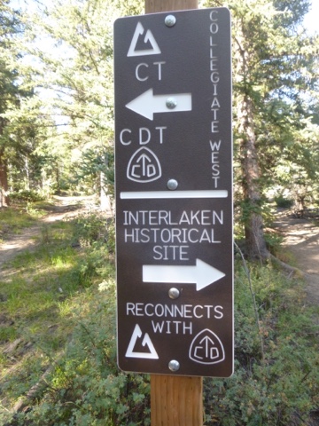
Our first destination was Interlaken, a ghost town. After we passed it, we did rejoin the CT and CDT.
Restored building: Dexter's Cabin
Can't get enough of this view - aspens turning yellow on the mountains
Turned right here, following CT and CDT
Mountains across the lake
Some steam crossings after this

We got confused here. Sort of straight on the left side was a no motorized vehicles sign - which I think was the route to Hope Pass. Sort of straight to the right of this sign is the footbridge over the Arkansas River. We went this way first - hoping to do a complete loop around the lakes - we got to a point where we saw the highway - and turned around - not realizing that this was the footbridge route. The river didn't look crossable around here. We then tried turning right at the sign. This brought us to the river and we did see the trail on the other side. The river was wide but looked like it could be easily forded (even by me, and I hate river crossings). We had no crocs and didn't want to ford barefoot or get our boots soaking wet so we turned around. At this point we retraced our steps back to Interlaken, giving up on a loop hike. We weren't positive if there were really trails that went all around the lake anyways, or if we'd end up walking along the edge of the highway. This would have passed right by the inn we are staying at though.
This looks like a jeep road that crosses the river???
River crossing which we gave up on
At the river a sign indicating you could bypass the ford by hiking to the footbridge which we didn't quite get to
Filtering water at the lake near Interlaken on the way back. A nice beach to relax at. See - I do go to the beach sometimes...lol.


No comments:
Post a Comment