
Miles: 7.3 (a bit longer than planned due to 1 wrong turn)
Time: 4 hours 37 minutes
Year to date miles: 183.1
Parking: Under Mountain Road, Joyceville, CT, just south of the intersection with Beaverdam Road. There is a blue sign on the road for Under Mountain Trail - the dirt parking lot is here. Room for around 15 cars (parking lot + roadside). The parking lot was full, so we had to park along the road.
Hike directions:
Blue blazed Under Mountain Trail (steady uphill climb)
Stay left at sign for Palisade Camp Area
Turn right onto Palisade Lane Trail (.1 miles after sign for Palisade Camp Area)
Palisade Lane Trail ends at the AT just over the Massachusetts border.
Turn left (south) onto white blazed AT.
Hike up steeply to Bear Mountain.
Continue south on AT.
Pass Bear Mountain Road on right.
Turn left on Under Mountain trail (blue blazed).
Follow Under Mountain trail back to parking area.
Map: South Taconic Trails
Hike description:
This hike is a counter clockwise lollypop loop.
The first portion of this hike is a steady, tiring up hill along the Under Mountain trail.
At the signed intersection for Palisade Camp area and Palisade Lane Trail, be sure to turn left (we turned the wrong way - which ended up taking us back to the trail we wanted to be on, but we didn't recognize it).
The climb up Bear Mountain on the AT is a steep rock scramble.
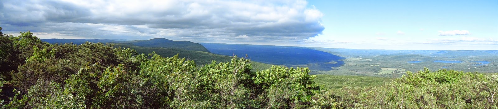
The view at the top of Bear Mountain is excellent.
The climb down Bear Mountain is less steep going southbound.
 |
| Sign on the road for the parking area |
 |
| Trailhead kiosk, just a little way down the trail from the parking area. The privy is to the left. |
 |
| I don't like snakes. But, I was brave, and took a photo of this garter snakes. We saw two. Almost stepped on both of them. They don't eat humans. |
 |
| Turn left at this sign. We turned right, and eventually ended up in the right place but didn't know it. We ended up backtracking. |
 |
| Shortly after the previous sign, turn right here, onto Paradise Lane Trail. |

 |
| The Paradise Lane trail ends at the AT. Turn left onto the AT. |


 |
| Bear Mountain Summit. Climb this for the view. |


 |
| Descending down Bear Mountain, there are several views. |
 |
| Turning left back onto Under Mountain trail |
No comments:
Post a Comment