Showing posts with label NY - Black Rock Forest. Show all posts

Sunday, February 2, 2014

Black Rock Mountain, Spy Rock, Eagle Cliff - Black Rock Forest

February 2, 2014
Distance: 7.3 miles
Time:  4 hours  27 minutes

Total elevation gain: 1766 feet

Map: West Hudson Trails Map

Parking: Mine Hill Road parking lot (just after hairpin turn). Room for 5 cars.


Restrooms: none
Post hike dinner: Jaipore, Yorktown Heights, NY

Directions:
Cross the street from the parking area
Mine Hill trail (yellow diamond)
Left on Sackett trail (yellow circle)
Pass Compartment trail (blue)
Left on Stillman trail (yellow rectangle)
Ascend Black Rock Mountain
Right on White Oak Road (unblazed)
Intersection at a large white oak tree
Left on Continental Road (unblazed)
Right on Scenic trail (white)
Right on Spy Rock trail (blue)
Ascend Spy Rock, then turn around
Right on Scenic trail (white)
Pass Ledge trail on right (yellow)
Pass Stropel trail on left (yellow)
Left on Eagle cliff trail (blue)
Ascend Eagle Cliff, then turn around
Left on Scenic trail (white)
Pass Chatfield trail (blue)
Left on Scenic trail (white) where Arthur trail (yellow rectangle) joins Scenic trail
Right on Scenic trail (white) where Arthur trail (yellow rectangle) leaves Scenic trail
Join Jims Pond Road
Right on Highland trail (blue) where Highlenad trail joins Scenic trail (white)
Pass Arthur trail on right (yellow rectangle)
Pass Chatfield Road on right (unblazed)
Go through gate
Pass Hall Road on left (unblazed)
Pass Split Roc trail on right (white)
Left on Compartment trail (blue)
Straight on Stillman trail (yellow) where Compartment trail goes right
Right on Sackett trail (yellow circle)
Left on Mine Hill trail (yellow diamond)
Arrive at parking area.

Notes: Slabs at ice near the beginning, but you can navigate around them. Slush snow for the rest of the hike. Nice views in spots. Met the same group of hikers a couple of times on the trail. The trails here have lots of intersections, so we had to frequently double check our map. The park has gravel roads that are occasionally used by scientists.

Year to to date miles: 37.6

Parking area

Trail head across the street from the parking area

This park has many yellow blazed trails with different shaped blazes.

View on the way up the steep climb in the beginning of the hike

Remains of a fireplace

Passing a gate


Ascending Black Rock Mountain

Summit

View from Black Rock Mountain

Summit marker, speckled with rain drops


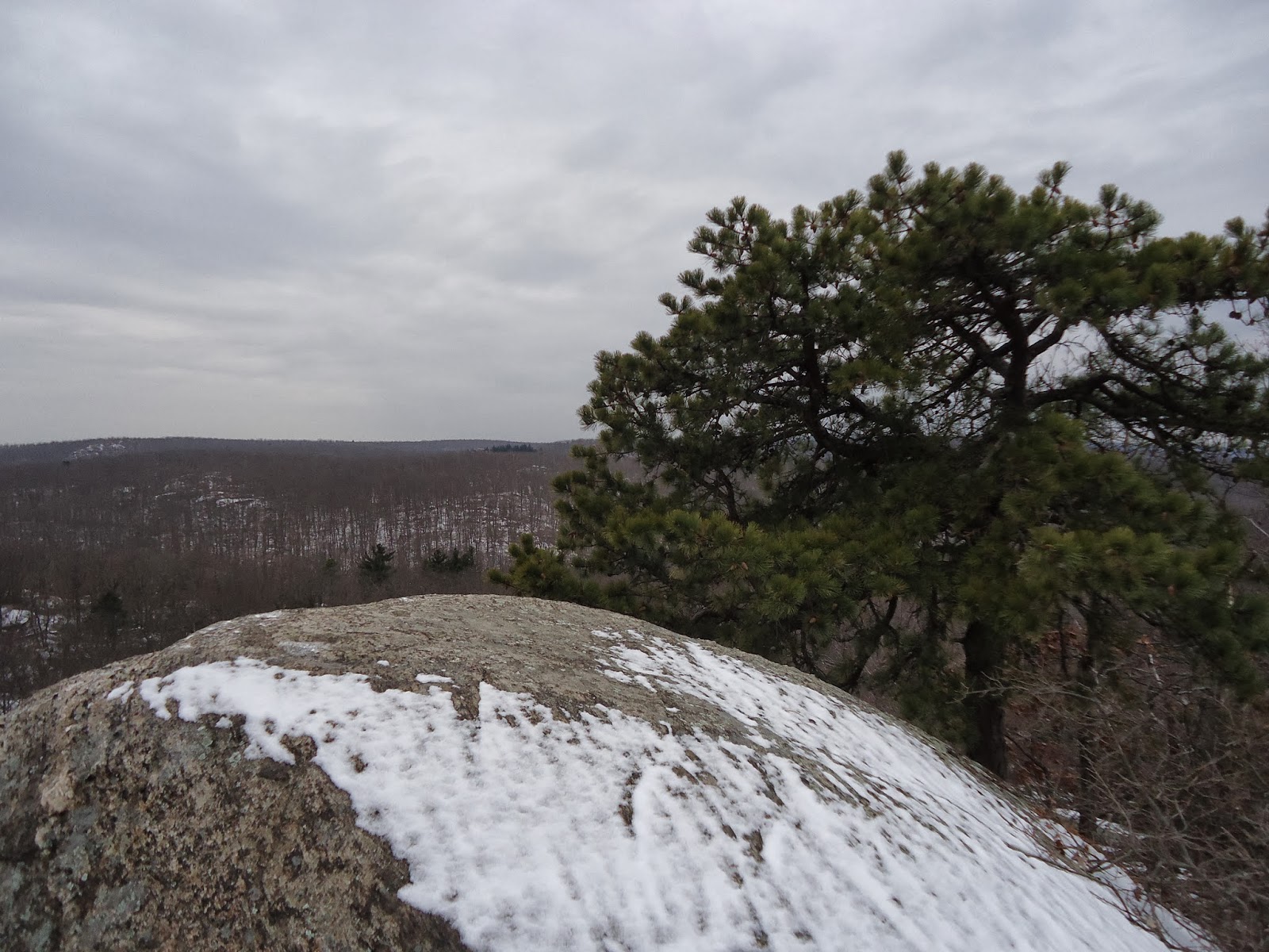
Spy Rock, with a pine growing out of the rock

Trail to Eagle Cliff

Eagle Cliff


View from Eagle Cliff

Monday, January 20, 2014

Whitehorse Mountain, Mount Misery, Hill of Pines, Rattlesnake Hill - Black Rock Forest

January 20, 2014
Distance: 5.9 miles
Time: 3 hours 22 minutes

Total elevation gain: 2,107 feet

Map: West Hudson Trails Map

Parking: From route 9W southbound, turn right onto Reservoir Road.Take right at T intersection. Follow to Black Rock Park. Parking area with room for around 15 cars.

GPS coordinates: 41.418627, -74.010401


Restrooms: none
Post hike dinner: n/a

Directions: 
Cross the street from the parking area, and take the yellow blazed Stillman/blue blazed Highland trails.
Continue up Whitehorse Mountain
Pass Upper Reservoir on your left
Where Stillman/Highland trails split, stay left on blue blazed Highland trail
Where Stillman rejoings from right, stay left on combined Stillman/Highland trails
Continue up Mount Misery
Left on white blazed Scenic trail
Continue up Hill of Pines
Cross Carpenter Road (park/woods road)
Continue up Rattlesnake Hill
Right on Meadow Road (park/woods road)
Pass Carpenter Road on your right.
Right on White Oak Road (park/woods road) where Meadow Road ends
Pass blue Swamp trail on right.
Pass yellow blazed Stillman/blue blazed Highland trail on right.
Left on yellow blazed Stillman trail 
Left on blue Reservoir trail, right before Reservoir Road
Cross Ben's bridge
Right on red Duggan trail
Arrive at parking lot.

Notes: First half of the hike is moderate/strenuous. Second half of the hike is easy. We saw no other hikers today, though there were other cars in the parking lot.

Year to to date miles: 24.1

Parking Area. The hike starts up the stone steps to the left of the gate.

Cross the park road and look for the yellow blazed Stillman trail and blue blazed Highland trail.

On the way up to Whitehorse Mountain

Wooded summit of Whitehorse Mountain

View of Upper Reservoir

Mount Misery summit


White blazed Scenic trail

Hill of Pines - very nice view


I do believe he's smiling


Rattlesnake Hill summit

Rattlesnake Hill summit

After Rattlesnake Hill, the second half of the hike is easy, often following woods roads


Sunday, September 29, 2013

Black Rock Mountain, Black Rock Forest

September 29, 2013
Distance: 5 miles
Time: 2 hours 41 minutes
Map: West Hudson Trails Map
Parking: From route 9W southbound, turn right onto Reservoir Road.Take right at T intersection. Follow to Black Rock Park. Parking area with room for around 15 cars.
Restrooms: none
Post hike dinner: n/a
Directions: Black Rock Mountain Circuit Via Footpaths and Woods Roads

Notes: The hike passes Aleck Meadow Reservoir (no swimming), which looked beautiful with the fall foliage. Nice views on Black Rock Mountain. Hulse Road is a gravel road, a little rough to walk on.

Year to to date miles: 306.2


Kiosk next to parking area. $2 per person donation suggested. We donated $5 (dogs are cheap!).


Large pipe crossing the stream. Turn right at the pipe.

Number on rock just after turning right at the pipe.

Pretty "pipeline" trail. Unblazed, but easy to follow. 
A view on the unblazed trail.

Approaching the reservoir. Turn right. 
Reflections in the reservoir. The dogs were disappointed we didn't let them swim. 
View from Black Rock Mountain.
The dogs entertained two young boys on the mountain who had a million questions about them.

Summit

Turning onto Hulse Road, which gets very gravelly (is that a word??)